Scientists at Newcastle University are part of a research team that has discovered an ancient river landscape preserved beneath the East Antarctic Ice Sheet.
The landscape appears to have been formed by rivers at least 14 million years ago and possibly even before the initial growth of East Antarctic ice around 34 million years ago.
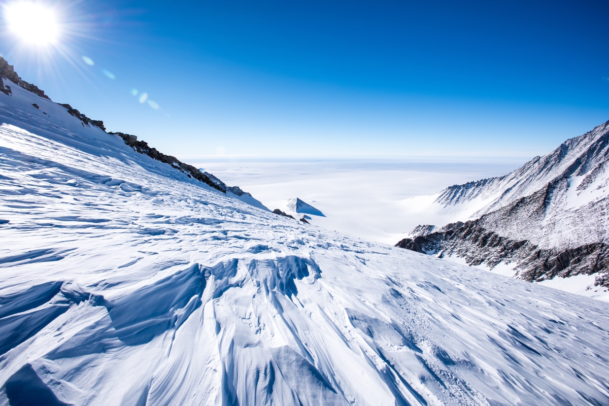
It consists of ancient valleys and ridges, not dissimilar in size and scale to the glacially-modified landscape of Eryri in North Wales, UK.
Published in Nature Communications, this discovery tells us important information about the early, and long-term, history of the East Antarctic Ice Sheet. It’s also helping us understand how it might evolve in response to future climate change.
The East Antarctic Ice Sheet
The East Antarctic Ice Sheet (EAIS) is the largest of Antarctica’s ice sheets. The impact of climate change and past fluctuations in the EAIS margin have been reflected in periods of extensive vs. more restricted ice cover, which have modified much of the Antarctic landscape.
Scientists have been able to conclude from global sea level change and ice volume records that there have been significant past changes in the EAIS. However, there is little evidence recording how much the ice margin retreated during past warm periods.
The landscape beneath the EAIS remains largely unknown, challenging our understanding of the EAIS and its response to historical, current, and future climate changes.
Mapping the land beneath the ice sheet
The research team, led by Newcastle and Durham Universities, used satellite and radio-echo sounding data to map a 32,000 km2 area of land underneath the vast ice sheet.
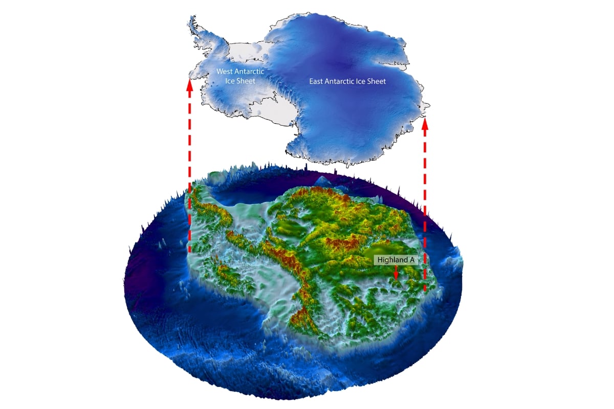
Graphic above ‘lifts’ the East Antarctic Ice Sheet off the bed landscape and highlights the study area (Highland A). The study area is in the Aurora-Schmidt subglacial basins, inland from the Denman and Totten glaciers of East Antarctica. Credit: Stewart Jamieson.
Although the landscape beneath the ice sheet is not visible to the naked eye, satellite images captured over the region show small undulations of the ice sheet’s surface that provide clues about the sub-ice landscape.
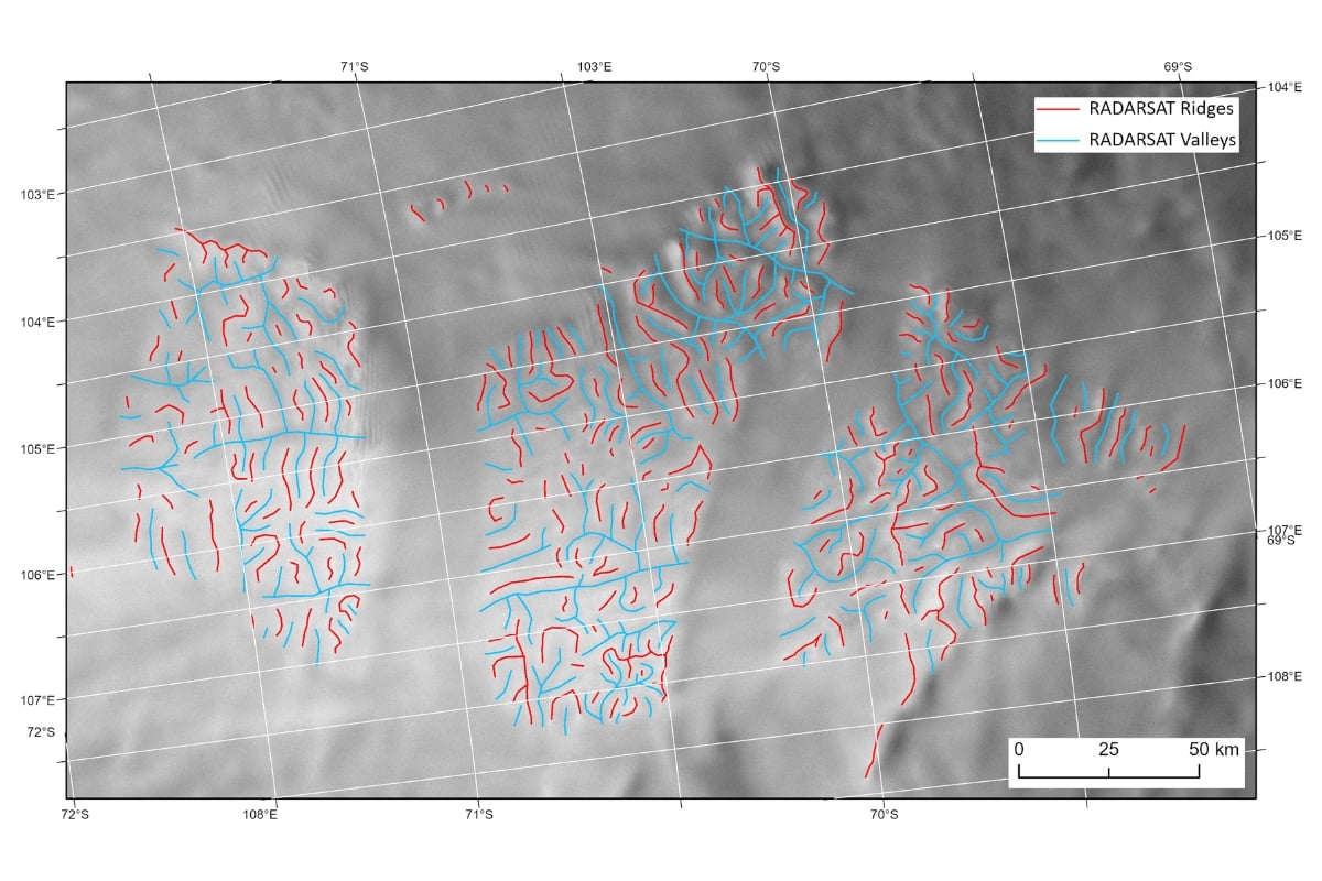
A satellite image showing the ridges and valleys of the ancient landscape, with the ice surface expression of the subglacial ridges highlighted in red and the subglacial valleys highlighted in blue. Credit: Stewart Jamieson.
Radio-echo sounding from planes confirmed the landscape’s existence and shape in a few places, confirming the mapping of the landscape beneath the ice sheet.
The survey data collection was supported by the UK Research and Innovation’s (UKRI) Natural Environment Research Council (NERC), the National Science Foundation (NSF) and NASA.
Hidden in plain sight
The team discovered an extensive relic pre-glacial landscape preserved beneath the central EAIS, despite millions of years of ice cover.
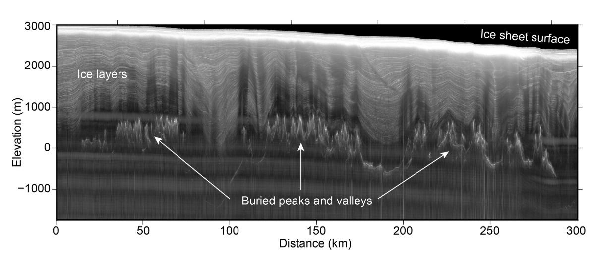
Radio-echo sounding data displaying the peaks and valleys of the mountains which are buried under ice that is 2 km thick. Credit: Stewart Jamieson.
The landscape consists of three river-carved upland blocks, separated by deep troughs. It was formed by rivers prior to ice sheet build-up but later modified by local glaciation before, or between, periods of ice sheet glaciation.
Findings indicate that there hasn’t been a substantial change in the subglacial landscape of this particular part of the EAIS, suggesting that although the ice sheet may have retreated during warmer times in the past, the sub-ice conditions at this particular site have not changed significantly.
This implies the long-term temperature of the ice sheet in the area investigated by the researchers has not changed significantly.
Future and ongoing warming
‘It is remarkable that this landscape, ‘hidden in plain sight’ for many years, can tell us so much about the early, and long-term, history of the East Antarctic Ice Sheet, and help us understand how it might evolve in response to future climate change.’
Prof. Neil Ross, Newcastle University
Understanding geological changes in the EAIS helps inform how it may respond to ongoing and future climate change.
The research team warns of potential threats posed by global warming to East Antarctica, highlighting the current trajectory towards atmospheric conditions like those between 14 and 34 million years ago when temperatures were 3C to 7C warmer than present. Under such anthropogenic forcing and the associated global heating, the research suggests that the EAIS may eventually retreat enough that local ice caps would once again exist on the ancient, preserved landscape.
Continuing Antarctic exploration
The discovery builds on previous work by the team who, in collaboration with other researchers, have mapped out hidden mountain ranges, canyon systems and lakes beneath the ice in Antarctica.
Future systematic mapping of the landscapes beneath the EAIS, along with sampling via direct bed access may provide significant new insights into its growth and past. There will likely be other, yet undiscovered, ancient landscapes hidden in plain sight.
You might also like
- read the paper: Jamieson, S.S.R., Ross, N., Paxman, G.J.G. et al. An ancient river landscape preserved beneath the East Antarctic Ice Sheet. Nat Commun 14, 6507 (2023). https://doi.org/10.1038/s41467-023-42152-2
- learn more about the study co-leads: Professor Neil Ross, Newcastle University and Professor Stewart Jamieson, Durham University
- read the latest press release: remains of ancient river landscapes control East Antarctica ice flow
- explore our School of Geography, Politics and Sociology and more of our Geography research